GPS to the Max
Among the great cosmic questions that plague mankind, “Where the hell am I?” is high on the list. Fortunately, technology offers a partial solution to this existential crisis in the form of GPS, or Global Positioning System, a satellite-based navigation tool that can pinpoint your position anywhere on the planet.
You probably were first introduced to a GPS device when some acquaintance who previously displayed absolutely no sense of direction suddenly started showing up on time because he had put one in his car and received dead-on routing for anywhere he might go. But in the almost two decades since satellite navigation instruments debuted to the general public they have been put to a slew of new uses beyond the world of automotives, including golfing, boating, running, tracking and keeping tabs on criminals. But the GPS system was actually developed for none of the above.
Who do we have to thank for this celestial push in the right direction? The U.S. military. In the days of the Cold War, Soviet nuclear missiles were mostly land-based and immobile, making them tempting targets. The U.S., though, had most of its nukes loaded onto submarines, and accurately aiming them required the subs to know exactly where they were shooting from. Hence the GPS system, funded at an initial cost of $12 billion, back when a billion was more than a rounding error in the federal budget. The first GPS satellite was launched in 1978, but it took until 1995 for the system to become fully operational.
How It Works
The GPS system, run by the U.S. Air Force, figures out where you are using trilateration—it’s similar to the triangulation in traditional navigation and surveying, but in three dimensions, since the signals sent from the satellites beam out in a circular pattern. Currently 31 GPS satellites are operational. At any given time the system uses 24 spread out to cover the globe, but keeps some spares up there at all times just in case. The satellites are also improved from time to time, and Lockheed Martin is now developing a more powerful, precise version called GPS III.
Fundamentally, the GPS system is all about timing. Each satellite sends out a uniquely identifiable signal with its current position and the time based on its built-in atomic clock, which is accurate to within a billionth of a second. Your GPS receiver latches on to as many satellite signals as possible. By comparing the time on earth with the time on the satellite, the receiver can figure out how far away it is from that satellite. Just one satellite signal tells you that you’re somewhere on a big three-dimensional sphere around that satellite. If you can lock onto three satellites, however, the receiver can figure out where those three spheres intersect and calculate where you are in two dimensions. Add a fourth and it can figure out your altitude as well.
The level of technological precision involved in these calculations is really pretty stunning as the radio signals from the satellites are traveling at the speed of light. In fact, when the system was originally made available outside the U.S. military, timing errors were intentionally inserted to keep enemies from being able to target too accurately. In May 2000, President Clinton removed this restriction and, in the process, kick-started the civilian GPS market, by providing greatly enhanced tracking capability.
Portable Navigation Devices
Yes, your smartphone probably has a GPS built in—the FCC wants all of them to have this capability by 2018—but while that’s great for finding your way while walking around town, it’s still troublesome when driving. The screen is small, the sound is low when pitched against road noise and you’re burning through already scant cell phone battery life. The dedicated portable GPS receiver, on the other hand, offers screens that are generous and sometimes positively capacious, they read out turn-by-turn directions loud and clear, and recent models have learned some very cool tricks.
One favorite is the TomTom Go Live 2535 M ($300), a unit with a five-inch screen that delivers an exceptional combination of navigation and information. “Live” is the key here: you get online access to a variety of live information services directly from the nav unit. Looking for the most inexpensive gas in the area? Tap the touch-screen. Want to perform a Google search, or find a restaurant on Yelp? It’s built into the unit and, what’s more, when the results pull up an address, you can tap it to navigate directly to it. The TomTom Live traffic service also goes beyond the standard road sensors to incorporate information from other drivers using connected units, and updates more frequently than standard traffic data systems. After the first year you will have to pay $9.99 a month for access to the Live services, but map updates for life are included with the unit.
Another unit worth considering, the Magellan Roate 9055-LM, brings the big-screen experience into your car, with a substantial seven-inch display (you’ll want to position it over the dashboard rather than the window, which is easy thanks to the long, flexible mounting bracket). The Magellan connects to your phone via Bluetooth, providing easy hands-free calling with great sound quality. You also get free lifetime traffic information, and access to AAA Tourbook guides. My favorite feature, though, is a $150 optional accessory, the Magellan Wireless Backup Camera. It isn’t entirely wireless, of course—you will have to plug it into the backup light circuit for power—but there’s no clumsy snaking of wires required between the camera in the back and the GPS unit up front. Suddenly you can see precisely what’s going on behind you, whether that’s an approaching bumper while parking or, far more important, a kid speeding by on a tricycle. If that’s not worth $150, I don’t know what is.
The Connected Car
Having a GPS system as part of your dashboard electronics is nothing new, but the latest trend adds more up-to-date information and entertainment options—connecting your car to the Internet while you’re driving. This means you have the latest map information, along with updated points of interest, instead of the aging data loaded into a traditional in-dash GPS Music isn’t limited to the junk food of commercial radio or even songs you’ve stored on an MP3 player—you can access streaming music services like Pandora for programming tailored to your tastes.
Depending on the system, you may even be able to keep up with Twitter and Facebook updates, order movie tickets or make a restaurant reservation from your car. And yes, you can make hands-free phone calls.
While some cars use their own built-in connection to the cellular network (the $50,000 Audi A6 Quattro, for example), most take advantage of the signal you’re already paying for and connect via your cell phone. Apps are created to display information directly on the dashboard screen, and to be compatible with the vehicle controls, whether that’s a touch-screen or steering-wheel buttons or both.
You don’t need to go the luxury-car route to have access to this technology; Ford, Hyundai and Toyota are all eagerly adding new online on-the-road features to their full range of vehicles. While car shopping, it pays to check out how the vehicle’s online system works with your particular phone model, though; some may not be compatible with your current handset at all, while some deliver different features depending on the connected phone.
Fortunately, you don’t have to buy a new car just to hop on the connected car bandwagon. Several manufacturers now offer aftermarket head unit systems with cell phone access to the Internet, which can be installed in a wide variety of existing vehicles. The Pioneer AppRadio 2 ($599) works with iPhone, iPhone 4s and specific Android models (you’ll find the list at http://bit.ly/ytpgtz). The system comes with cables for the iPhones it services. However, Android owners will have to pony up
another $100 for a connectivity kit specific to their models.
At this writing there are 17 apps available for iPhone s and nine for Android, some free, others paid, with more added monthly. These include numerous streaming music sources, turn-by-turn directions and current traffic reports, local parking lot recommendations, access to your phone-based calendar information and even (when you’re parked) the opportunity to show off your favorite digital photos in a slideshow. Voice control, as found in some car manufacturer’s original equipment systems, would be a nice addition to the next version of the product, but at least you can toss your phone in the glove compartment and access any controls you need via your car’s dashboard controls, with control layouts carefully tuned for easy access even while driving.
Your Link on the Links
When it comes to tackling your favorite golf course, and especially an unfamiliar course, a few key positional factors make all the difference: how far your lie is from the hole; how far you are from that nasty-looking dogleg, or sand trap; and what unpleasant surprises await beyond the tree line, where the fairway is just out of sight. All of that information can be yours with pinpoint precision thanks to portable GPS systems.
One of the most impressive solutions can be worn right on your wrist, as a watch. The Garmin Approach S3 ($350) is a handsome waterproof touch-screen timepiece preloaded with the layouts of over 28,000 courses worldwide. You get a visual image of the green along with distances to the front, back and middle of the green, plus layup and hazard distances. Looking for bragging rights after that last great drive? The Garmin S3 will measure shot distances precisely (unfortunately, there doesn’t appear to be a way to dial in a little “sweetener”). If you choose to use the watch to keep score, you can track individual player performance, then save the results to your computer when you get home and print them if you like (erasing is also a viable option, of course).
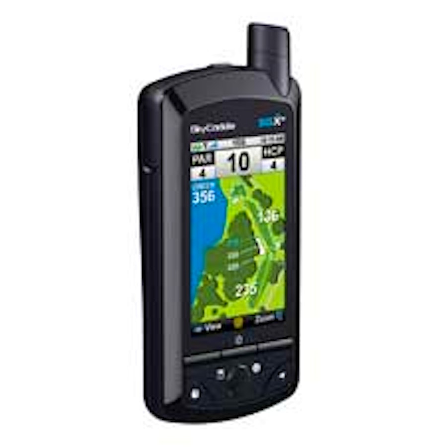
For the ultimate fairway GPS companion, we sacrifice wrist-based portability for the hand-held SkyCaddie line. You get a three-inch color screen with detailed views of almost 30,000 courses—the company actually sent people to walk the courses to get accurate measurements, a job that’s as valuable to you as it probably was boring to them. Want a closer view of a fairway feature? For an increasing number of courses an interactive zoom feature delivers precisely the view you need.
A practical touch in the product design is the lack of touch required—instead of a touch-screen, which would quickly become grimy on the course, you get a precise, easy-to-use optical trackball. And the latest model, the SkyCaddie SGXw ($400), adds another tech enhancement in the form of wireless Wi-Fi hotspot access for ing course layouts (the version without Wi-Fi, nearly identical otherwise, runs $50 less).
Which does bring up one glitch in the SkyCaddie system. While basic course information is preloaded into the system, you have to be a member to access the detailed maps you really want. Annual hip (for unlimited s) runs $30 within a state, $50 nationwide and $60 worldwide. Not exactly chump change—but you can probably win it back quickly enough off the opponent who can’t figure out precisely where to lay up when confronting that nasty sand trap on the back nine.
Run!!!!!!
Alright, I confess right up front that if Godzilla were clomping his way up Fifth Avenue looking for a tasty tidbit, I’d probably be the first piece of kosher sushi he’d grab—a runner I’m not. But as a tech aficionado, I can certainly appreciate the ways GPS has been used to make training more manageable, easier to track and, if you’re the type, I suppose enjoyable.
One of the most impressive products I found is the Nike+ SportWatch GPS ($150). This is actually a two-part system, which to me is a significant part of its appeal. Many of you have probably seen those little oval pucks Nike developed in concert with Apple a few years back for their Nike+ iPod Sport Kit. It fits neatly into a special compartment under the lining in select Nike sneakers, but works just fine tracking your paces if you simply tuck it into a standard shoe, or even under the laces. The point here is that you are getting both a GPS-equipped watch, which will track your movements with pinpoint precision when loping along under blue skies, and the shoe sensor, which does the same when running under tree cover or even indoors—a winning combination.
It’s a reasonably comfortable, good-looking device—a little large for everyday wear, but without the medical-equipment look you find with some competing products. While running, the basic display shows how far you’ve run, and a quick button press will bring up additional info including elapsed time and calories burned. The slick part happens when you get home and use the well-designed USB connector to your results to the free Nikeplus.com web site. Here you can see your course displayed on a map, obsess over every minute detail of your performance and get advice on enhancing your training regimen. Hmm…. Maybe if I start using the Nike+ system now, I will survive that Godzilla attack. After all, I don’t have to run faster than Godzilla…. I just have to run faster than you.
If you prefer a more comfortable and wide-ranging training experience, Motorola’s MOTOACTV GPS fitness tracker and music player ($250 for 8GB, $299 for 16GB) could be more your speed. In addition to a capable built-in GPS to monitor your movements, the Motorola system s optional wireless Bluetooth headsets (the unit comes stock with more pedestrian wired buds), so you can enjoy your favorite workout mix without accidentally garroting yourself when you need to scratch an itch. The system can also pair wirelessly with a Motorola phone for data display and exchange, but only with Motorola devices, so it’s best employed with a Droid. But even the rest of us get access to a very capable, free web-based service (connecting via Wi-Fi). And unlike the Nike+ system, which is limited to tracking running, the accelerometer-based Motorola has multisport potential, with for cycling, elliptical machines, martial arts and even snowboarding.
On the Right Track
We think of a GPS system as a way to figure out where we’re headed, but if you combine the satellite location technology with a cellular radio, all of a sudden you can figure out where something else is wandering—your dog, your grandma, your car. That’s what PocketFinder from LBT offers, with compact devices that can be tracked via the web or smartphone.
The basic PocketFinder tracker ($150) is just two inches across and an inch deep—it fits easily in the palm of your hand. It comes in two nearly identical versions—only the clip provided distinguishes between the People version and the Pets version. Of course, there’s no reason you can’t attach one to your briefcase, backpack, belt or pretty much anything else you’d like to track. These versions are rechargeable—figure a charge will last two or three days. They’re rugged, too, impervious to water, dust and shock. There’s a different configuration for vehicle tracking ($190) that installs permanently and connects to the car battery. You sacrifice clip-it-to-anything portability, but don’t have to worry about periodically attaching the device to the charging base.
When you to the PocketFinder service you’ll not only see a Google Map view of the device’s current location, but also its velocity, current speed and direction, and have access to a 60-day history of locations visited. You can also set alerts, with notifications via text message, email or mobile app if the device exceeds a speed limit you set, or travels outside an area you specify. I found the PocketFinder portable device extremely sensitive, (it located a signal indoors where portable GPS
navigation systems had no luck). There’s no service charge for the first two months, then it’s $12.95 a month in the U.S. and Canada, and 29.95 internationally. A reasonable price for keeping tabs on kids and pets and making sure your teenager isn’t speeding toward Vegas at 90 mph.
Legal Peek-a-Boo
As for those scoundrels who read Cigar Aficionado (yes, I’m talking to you, Tony Soprano), it’s been a year of mixed news. In early 2012, the Supreme Court ruled that it’s illegal for law enforcement officials to attach a GPS tracking device to your car without a search warrant. Ah, but what about that handy tracking device you’re already carrying along with you—your GPS-equipped mobile phone? Just ask Melvin Skinner, a.k.a. “Big Foot,” who was apprehended hauling 1,100 pounds of marijuana in a motor home out of Mexico. The authorities got the number of the phone he was carrying, and the GPS data took them right to his Texas motel doorstep. Melvin argued this kind of tracking violated his Fourth Amendment rights, but the 6th Circuit court wasn’t buying it. In fact, it compared this process to using a suspect’s scent to track him down.
So there you have it, my friends. If you can’t do the time—or the place—don’t do the crime.
Contributing editor Steve Morgenstern writes about technology for Cigar Aficionado.